Hawaiian Islands:ハワイ諸島
Map of the Hawaiian Islands, a chain of islands that stretches 1,500 mile (2,400 km) in a northwesterly direction from the southern tip of the island of Hawaii.
ハワイ諸島(1,500マイル(2,400km)をHawaiiの島に関する南端から北西の方向に伸びる列島)の地図。
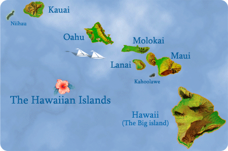
The Hawaiian Islands (Hawaiian: Mokupuni o Hawai‘i) are an archipelago of eight major islands, several atolls, numerous smaller islets, and undersea seamounts in the North Pacific Ocean, extending some 1,500 miles (2,400 km) from the island of Hawaii in the south to northernmost Kure Atoll (the northwesternmost island in Hawaii is Green Island, which is joined to the Kure Atoll). Excluding Midway, which is an unincorporated territory of the United States, the Hawaiian Islands form the U.S. state of Hawaii. Once known as the "Sandwich Islands", the archipelago now takes its name from the largest island in the cluster.
ハワイ諸島(ハワイ語: Mokupuni o Hawai、‘Hawai)は、の島から約1,500マイル(2,400km)広がっていては、8つの主要な島、いくつかの環礁、多数の、より小さい小島、および北太平洋の海中海山の諸島です。--最北のクレ岩礁(ハワイの最北西部の島は、クレ岩礁に接する緑島である。 ミッドウェイ(合衆国の組み込まれていない領土である)を除いて、ハワイ諸島はハワイの米国州を形成します。 「サンドイッチ諸島」としていったん知られているが、諸島は、現在、クラスタ(島群)で最も大きい島から名前を取ります。
The islands are the exposed peaks of a great undersea mountain range known as the Hawaiian-Emperor seamount chain, formed by volcanic activity over a hotspot in the Earth's mantle. At about 1,860 miles (3,000 km) from the nearest continent, the Hawaiian Island archipelago is the most isolated grouping of islands on earth.
島は、地球マントルで火山活動によってホットスポットの上に形成された、ハワイの皇帝海山列として知られているすばらしい海中山脈の露出しているピークです。 最も近い大陸から約1,860マイル(3,000km)では、ハワイの島の諸島は、地球上で最も孤立している群島です。